Friday, 25 June 2010

Sheeps Tor and Burrator Reservoir

start point SX559679
distance 8.5 miles
time 4 hours
Guiness enjoyment rating 7

Hestitated before putting this blog entry 'out there' - would not recommend this particular route to anyone.  I only went this way to find 4 x geocaches(new hobby, blame Phil) so there was a bit of scrambling through the bracken involved.  Started at the southern end of Burrator Reservoir and climbs to Sheeps Tor.


The view form atop the tor looking back over Reservoir is stunning.


From here I headed through the Roughtor plantation along the Narrator Brook to emerge south of Combshead Tor where there is a lovely view looking back...


I then headed in a north easterly direction (so said the compass) to find a cache and then westerly along a stone row toward Down Tor


The best route back from Down Tor would be simply to continue east and back to the reservoir but I headed south to find my final cache of the day and then I got a bit lost and waded through unexpected bracken and was a bit glad to reappear near Nosworthy Bridge.  A pleasant amble next to the reservoir found us back at the car...

Thursday, 24 June 2010

South Tawton Common

Start point SX647933
Distance 7.5 miles
Guiness enjoyment rating 8
Time 3 hours

Starting from South Zeal this walk explores South Tawton Common, visiting Little Hound Tor and the Cosdon Beacon.  I suspect sections would be quite boggy after heavy rain but today it was nice and dry.  Walking up past Newlyn Cottage there are various routes to take but I headed east in an anti-clockwise direction between stone walls which open slowly open out onto the moor.


On the OS map there appears te be a well defined path along the western side of the common I couldn't find it and a bit of judgement is required before you reach the ford at 'White Hill'.  This area is great walking territory.


Climb the hill to reach Little Hound Tor.  There's not much here to look at so we'll have a close up of Guin instead...


Heading due north for a mile takes you to Cosdon Beacon...


And then various options open out to take you back to the start.  Not a challenging walk but well worth doing.

Monday, 21 June 2010

Princetown and Bellever

Start point SX593739
Distance 15.5 miles
Guiness enjoyment rating 8
Time 7.5 hours


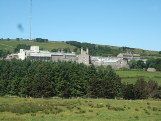
Starts at the layby overlooking Princetown prison. Good place to go when you need to tell yourself things could be worse. A short walk along the road toward the town and turn left to find yourself on Dartmoor Way, an easy to follow route that can eventually take you to Dartmeet, but we veered off just after a lovely section near Swincombe.


Head north along thew West Dart through possibly the most beautiful area of Dartmoor, where there are two sets of Stepping stones to overcome. Guiness managed the first ones fine but then came up against the 2nd...


Worth mentioning that at the entrance to this section there is a notice saying that dogs are not allowed along this part so if you are bringing your dog I advise you not to read the notice. Crossing over the B3357 you will find yourself on route to Bellever Tor...


...where Guin insisted we have a picture taken together (it's his birthday).

Crossing over the B3212 takes to up to Longaford Tor but this section does require a tad of navigation to find a route that doesn't leave you waist deep in mud (slight exaggeration maybe).  Further East and you pass Wistman's Wood and then Beardown Tors and then follow a southerly route toward Two Bridges.  We were slightly set upon by a herd of cows soon after.  Guiness, to his credit, remained very calm but we were both relieved to reach the gate!


A very long but very enjoyable walk.

Friday, 18 June 2010

Short walk from Dartmeet

Start SX672732
Length 4.5 miles
Time 2hrs
Guiness enjoyment rating 7.

Everything seemed to go wrong with this walk.  It starts by crossing the stepping stones at Dartmeet.  If you look very closely at the pic you can see a dog at the far end refusing, as usual, to get his paws wet.  Fortunately it was easy to retrieve him and carry him across.


The walk continues through very pleasant farmland and a climb through bracken which has various routes so checked with my new GPS Satmap to check I was on the right route...Satmap not working...take batteries out and try again but all going haywire when I turn it back on.  Something to sort out later.  Dad was trying to convince me only yesterday that it would be a good idea to take a compass on Dartmoor 'just in case'.  Neil 0 -1 Dad.

Carrying on up the hill you meet the road where you turn right.  More cars than you might expect along this stretch so decided to out Guiness on a  lead...No lead...Must have left it behind when I carried him over the stepping stones.  Anyway had a strap for the GPS so thought I could attach this to his collar instead...no collar.  Remembered I'd taken it of the evening before.  Doh!  Anyway, dodged to traffic to reach Combestone Tor.


View of the Dart form Combestone Tor

After the tor you cut right and follow the pathway, bearing left at the signpost, to more stepping stones and at Huccaby Farm head eastwards back to Dartmeet. A slight detour back to the Stepping stones located the missing lead (and also my sunglasses which I'd also lost without realising it).

A nice easy walk.

Tuesday, 15 June 2010

Around Merrivale

Start point SX530751
Time 5 hrs +
Distance 12.75 miles
Guiness enjoyment rating 9 (still chasing his ball after 11 miles!)


This is a great walk. Long but not arduous and contains some fantastic scenery. Starting at the final car park/viewpoint along the B3357 between Two Bridges and Tavistock the view leading down Whitchurch Common just begs for you to get out and walk. From Pew Tor the walk goes along tracks and farmland through Samford Spinney and up a steep road before entering Walkhampton Common. This section requires you to snake through the gorse but it's worth the effort (not that you've got much choice) as you get a lovely view look backing as you reach the top and onto Dartmoor Way, heading East toward Princetown.


From Princetown you head up the hill toward the Television Mast. The mast was built in the late 1950s following a riot at the nearby prison when convicts took the Governor hostage and threatened to mess up his filing system if they didn't get better tv reception. Conditions are tough at the prison but they do get ITV2, 3 and 4. Over the hill from the mast and you rejoin the B3357. Go straight ahead and follow the track uphill to Great Mis Tor. This takes you right to the edge of the Merrivale Range Danger Area. Guiness, who is braver than me, chose to pose for the camera in front of the red flag, just to tell the army who is boss. On a serious point, do not enter this area when the flags are showing because if you do the army will shoot you.


Heading east this was my favourite section of the whole walk with the rocky landscape looking over at Great Staple Tor leading down to the River Walkham.


Guiness struggles with rivers, or even streams.  Puddles are about his limit.  It was only when I told him it was either get across or walk the 12 miles back the way we came that he plucked up the courage and got his paws wet.


Sunday, 13 June 2010

Hayne Down, Jay's Grave and Becky Falls

Manaton is an excellent place to start exploring the moor; Haytor Down, Hayne Down, Houndtor Down and Lustleigh Cleave are all in easy reach. This walk starts from the car park next to Manaton church where you head down the road from the crossroads and up a steep climb to the top of Hayne Down where there are some lovely views...


From here it is a short stroll down the hill and turn right along some fields with sheep. This gives Guiness a chance to show off his skills with sheep, not at rounding them up but at having no idea that as a collie he should chase them. They don't even seem bothered by his presence. Have you no self respect Guin?


Further along and you soon come to 'Jay's Grave'. The grave (apparently) contains the remains of Kitty Jay who worked on a nearby farm in the late 18th century. She was raped, became pregnant and, unable to cope with the shame, committed suicide. None of the local parishes would give her a proper burial so she had to be laid to rest elsewhere. One of the things I love most about Dartmoor is how very little has changed in hundreds of years. I'm glad some things have changed.


Along the road to Swallerton Gate, turn east across Houndtor Down.

Houndtor
Guiness is a bit bonkers

This leads to the western edge of Haytor Down before you follow the paths and road to Becky Falls. You can't access the paying public areas unfortunately but it is still a lovely stretch. Soon after you join the 'Dartmoor Way' before a left turn takes you back to Manaton.

start point sx749811
distance 7.5 miles
approx time 3.30 hours
Guiness enjoyment rating 8

Saturday, 12 June 2010

Steps Bridge Circular walk

Steps Bridge is located on the northern edge of Dartmoor and though it lacks the open moorland associated with the moor it is nevertheless a lovely, picturesque walk. The reason it is called 'Steps' Bridge is unclear but locals tell me that the pop group 'Steps' crossed the bridge in the late 90s and this may be the derivation.

Park at the car park over the bridge and head along the south side of the River Teign. After 1/2 mile you have the option of a left turn for a short uphill loop but instead turn right and continue along the river. Although you can continue right along to Clifford Bridge, the final few hundred yards is not open to walkers so instead turn left up a steep climb and loop around to the right and then down the road to the bridge. Follow the road to the other side of the river and walk back to Steps Bridge.

start point sx803882
distance 5 miles
approx time 1hr 50mins
Guiness enjoyment rating 7/10 (8 if he gets an additional biscuit at the bench on the final stretch)


Guiness has a disntinct lack of vigour in trying to find his ball on a rope when he loses it. Watch him in action.