Start Point; Haytor Distance 5 miles
Time 2 hrs
Guiness enjoyment rating 8/10
Although Haytor is the most well known and easily accessible tor on the moor it also is a great place to walk (and not just a quick loop around the rock and back to the car).
Pictures to follow when I can find my camera cable.
Friday, 15 July 2011
Friday, 3 June 2011
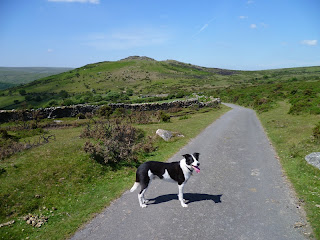
Newbridge and Dr Blackall's Drive
Start Point; Newbridge
Distance 12 miles
Time 5 hrs 45 mins
Guiness enjoyment rating 9/10
On a gloriously sunny, with new camera in hand (or rather in carry case looped very securely around my neck) we were off to the moor again. No exploring today, but mostly along tried and tested routes. From Newbridge there is a climb before you enter the moor and onto Dr Blackall's Drive (This carriageway was laid down by the lord of Spitchwick Manor in the late 19th century).

If you only ever walk once on Dartmoor give this one a go. The views are wonderful.
.

And then onward and downward to lovely Dartmeet. People often mistakenly think this is where the East and West Darts meet. Oh no, hang on, just checked the map, yes that is right actually.

Heading north along the West Dart we come to the point that was giving Guiness sleepless nights - the stepping stones. No set of pictures on this walk would be complete without Guiness refusing to cross the River. It was fine, in the end I just carried on and he ran back to the car and waited for me.

The return leg - another view of Sharp Tor

And just a few yards before the end at Spitchwick. I think we went here as kids - it's a lovely family spot.

Another long walk, but Guiness and I loved it.
Distance 12 miles
Time 5 hrs 45 mins
Guiness enjoyment rating 9/10
On a gloriously sunny, with new camera in hand (or rather in carry case looped very securely around my neck) we were off to the moor again. No exploring today, but mostly along tried and tested routes. From Newbridge there is a climb before you enter the moor and onto Dr Blackall's Drive (This carriageway was laid down by the lord of Spitchwick Manor in the late 19th century).

.

After a couple miles the 'Drive' turns into the Two Moors way before I veered off toward Sharp Tor

And then onward and downward to lovely Dartmeet. People often mistakenly think this is where the East and West Darts meet. Oh no, hang on, just checked the map, yes that is right actually.

Heading north along the West Dart we come to the point that was giving Guiness sleepless nights - the stepping stones. No set of pictures on this walk would be complete without Guiness refusing to cross the River. It was fine, in the end I just carried on and he ran back to the car and waited for me.

The return leg - another view of Sharp Tor

And just a few yards before the end at Spitchwick. I think we went here as kids - it's a lovely family spot.

Another long walk, but Guiness and I loved it.
Wednesday, 1 June 2011
Merrivale Firing Range
Start Point; Two Bridges
Distance 12 miles
Time 5 hrs 30 mins
Guiness enjoyment rating 8/10
No photos today. I did take some but half way along the camera stopped working. I'm no expert but I think it's because it fell in the river a few seconds earlier. Oh well, an excuse to treat myself to a new one. Will try the Picture card in another camera, they might live on after all.
This walk is almost entirely within the Merrivale Range Danger Area which you can only enjoy when there is no live firing by the Army. You are strongly advised not to enter when there is live firing as you certainly won't enjoy it if they shoot you. The first half of the walk is the most enjoyable, passed Wistmans Wood and up over Cocks Hill to the standing stone just shy of White Tor.
The return leg is very well defined on the map but poorly on the ground and was marshy and boggy in places, fueled by recent rains and various leats and streams. It was getting a bit frustrating and I think it was when crossing one of the leats that the camera decided he'd had enough and made a run for it.
Guiness had a great time, chasing his ball on the first half and keeping close by in the latter stages in the false belief that I knew where I was going.
Friday, 20 May 2011
Avon Dam Reservoir
Start Point; Shipley Bridge
Distance 11 miles
Time 4 hrs 45 mins
Guiness enjoyment rating 8/10

We're back. This walk starts at Shipley Bridge, east of South Brent and follows a road toward Avon Dam Reservoir.

After all the recent dry spell I was expecting the Reservoir to be half empty but was pleasantly surprised that it was half full, slightly less after Guiness had a mouthful.

This photo - toward Pupers Hill is about 4 miles later after an eastward turn along Abbots Way and then a short road section via Cross Furzes.

The origins of this circular stone section are unknown, at least to me.

The final stretch is along an old Dismantled Tramway. I wasn't entirely sure I was going in the right direction, but Guiness seemed to know the way. A longer walk that I was planning but Guiness had no complaints.
Sunday, 15 May 2011
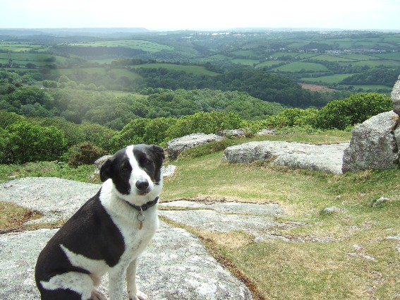
Cadover Bridge
Start Point; Cadover Bridge (River Plym, 2 miles sw of Yelverton)
Distance 7 miles
Time 3 miles
Guiness enjoyment rating 8/10
A venture to the Southwestern side of the moor, this walk starts from Cadover Bridge...

and heads west thought lovely North Wood

We then headed to a viaduct where some people were risking life and limb abseiling for charity.

A stray wolf made a brief appearance.

Heading north we soon came to a tunnel. Guiness was naturally wary as he'd heard of the bright eyed monster that hid within. I found it really dark inside but being the clever thing I am I worked out (eventually) that I could improve this by taking off my sunglasses.

After heading east through we then climbed to Dewerstone Rock where Guiness insisted on posing for the camera.

And then it was a leisurely stroll across Wigford Down and back to the car.

Distance 7 miles
Time 3 miles
Guiness enjoyment rating 8/10
A venture to the Southwestern side of the moor, this walk starts from Cadover Bridge...

and heads west thought lovely North Wood

We then headed to a viaduct where some people were risking life and limb abseiling for charity.

A stray wolf made a brief appearance.

Heading north we soon came to a tunnel. Guiness was naturally wary as he'd heard of the bright eyed monster that hid within. I found it really dark inside but being the clever thing I am I worked out (eventually) that I could improve this by taking off my sunglasses.
After heading east through we then climbed to Dewerstone Rock where Guiness insisted on posing for the camera.
And then it was a leisurely stroll across Wigford Down and back to the car.

Friday, 22 April 2011
Short loop form Bennett's Cross
Start Point; Bennett's Cross (on B3212, 2 miles from Postbridge)
Distance 5.5 miles
Time 2.hrs 15 mins
Guiness enjoyment rating 7/10
A little tiddler to start another season of walks on dartmoor with Guiness. I choose not to walk on Dartmoor during winter; personal safety and welfare are improtant to me and in winter there is a hightened chance I might get wet.

This walk starts from Bennett's Cross and starts along the Two Moors Way before almost immediately veering south to Headland Warren Farm.


It then follows a path to 'the medieval village of Challacombe'...

before looping around and arriving back at the start via Soussons Down. NIce little walk.
Saturday, 27 November 2010
Okehampton and Belstone
Start Point; Okehampton
Distance 9 miles
Time 3.hrs 30 mins
Guiness enjoyment rating 9/10
My favourite walk on Dartmoor! Have done this 4 times now- it has everything; riverside woodland sections, rolling farmlands and a section of wild open moorland which is Dartmoor at its best. The snows had fallen overnight and I knew it would look stunning today and indeed it did.
The walk starts at Okehampton...

and follows the river near the castle...

before we fork right to take an uphill section through woodland to the road that leads to the moor.

At the top of the climb we veer left for a stretch on private road where Guin enjoyed a play with his ball...
Next to an isolated farm which acts as an entrance to the wild moorland section of the walk. Loads of Shetland ponies about today. The views here were, as Bernard Mathews would have said had he not died yesterday, bootiful.

This section of the walks link up with South Tawton Common that we did back in June. At the most isolate section today the mists descended but was I worried? What me, experienced moorman that I am?

The pathway here leads back to Belstone.

Across farmland finds you at the final stretch along the river at East Okement (when it started snowing) before arriving back in Okehampton.

Subscribe to:
Comments (Atom)